Manaslu Circuit with Tsum Valley Trek 20 Days
US$1299US$2500
Book Now

Manaslu Circuit with Tsum Valley Trek 20 Days

1530+ reviews in TripAdvisor
400+ reviews in Google
106+ reviews in TrustPilot
Trip Facts
Duration25 Days
Trip GradeModerate - Strenuous
CountryNepal
Maximum Altitude5167 m
Group Size2-15
StartsKathmandu
EndsKathmandu
ActivitiesTrekking/Hiking
Best TimeMarch, April, May, Sep, Oct, & Nov
Overview

The Most Complete Expedition Into Nepal’s Hidden Himalayan Civilization

This journey is not simply a trek around a mountain. It is a passage through one of the last regions of the Himalaya where geography, history, belief systems, and daily survival still form a single continuous way of life. The Manaslu Circuit with Tsum Valley Trek 20 days follows ancient routes that connected the Indian subcontinent to the Tibetan plateau long before modern borders existed. Salt, wool, grain, and ideas once moved through these valleys carried by caravans of yaks and traders who navigated terrain that remains largely unchanged.

Mount Manaslu rises to 8,163 meters and dominates the region not only physically but culturally. Its name comes from the Sanskrit word manasa, meaning intellect or spirit, reflecting its perceived sacred presence. The peak was first climbed on 9 May 1956 by Toshio Imanishi of Japan and Gyalzen Norbu, a Sherpa climber, yet the surrounding valleys remained isolated from international travel for decades. Tsum Valley itself opened to foreign trekkers only in 2008, making it one of Nepal’s most recently accessible high Himalayan regions.


Seasonal Operating Windows With Precise Timing

Weather in this part of Nepal is controlled by the South Asian monsoon cycle and winter snowfall patterns. Safe and visually rewarding travel occurs within clearly defined periods.

Season Operational Months Conditions on the Ground
Spring Mid March to Late May Stable temperatures, blooming rhododendrons, long daylight hours
Autumn Late September to Mid November Clear skies, sharp mountain visibility, dry trails
Winter Late November to February Extreme cold, heavy snow above 4,000 m, possible pass closure
Monsoon June to Early September Landslides, swollen rivers, persistent cloud cover

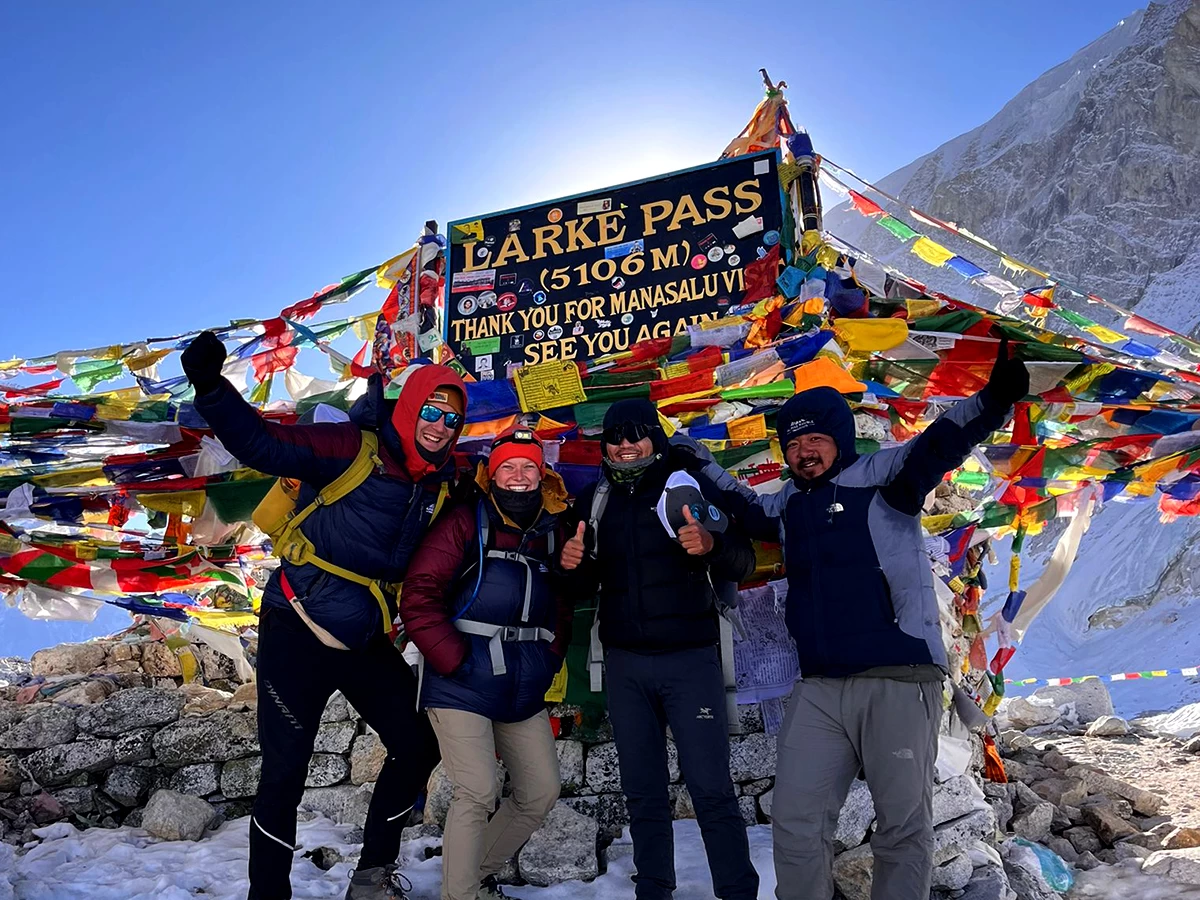
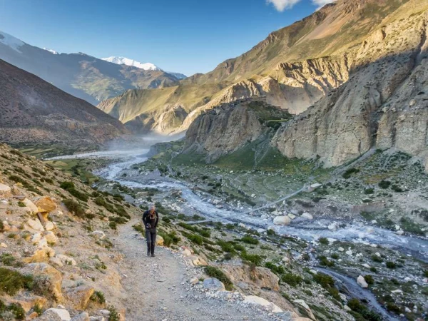
The Larkya La Pass at 5,106 meters typically becomes reliably crossable from late March onward and again from late September until heavy winter storms begin.


Geographic Structure of the Expedition

The trek traces the Budhi Gandaki River northward from low subtropical elevations to the edge of the Tibetan plateau before crossing westward into the Marsyangdi basin.

Elevation progression

Zone Elevation Range Environmental Characteristics
River Gorge 700 to 1,500 m Humid forests, waterfalls, terraced farms
Mid Hills 1,500 to 3,000 m Pine and rhododendron forests, Gurung villages
Upper Valley 3,000 to 4,000 m Alpine terrain, Tibetan cultural influence
High Himalaya 4,000 to 5,106 m Glacial landscape, sparse vegetation

This vertical transition compresses ecological zones equivalent to traveling from tropical plains to Arctic tundra within less than three weeks.


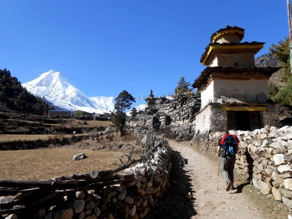
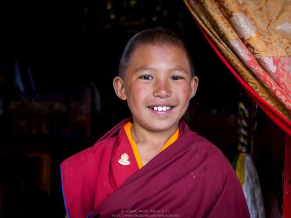
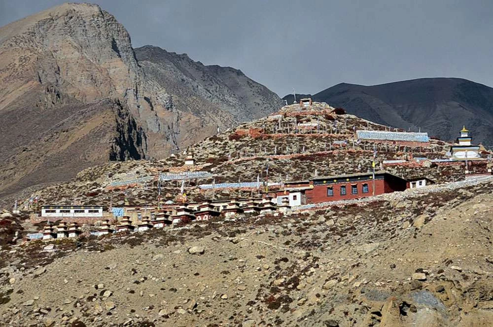
Tsum Valley as a Preserved Cultural Enclave

Tsum Valley branches east from the main Manaslu route and remains one of the most culturally intact Tibetan Buddhist regions outside Tibet itself. Historical records and oral traditions suggest settlement began over a thousand years ago. The valley is associated with Guru Padmasambhava, an 8th century Buddhist master credited with spreading Vajrayana Buddhism across the Himalaya.

Important religious sites include:

  • Mu Gompa, a major monastery near the Tibetan border founded in the 19th century
  • Rachen Gompa, a large nunnery housing several dozen resident nuns
  • Numerous meditation caves linked to hermit traditions
  • Extensive mani walls carved with Buddhist mantras

Local customs historically prohibited animal slaughter within the valley, reflecting a strong ethic of non violence rooted in Buddhist teachings. Even today, cultural continuity is visible in architecture, clothing, and agricultural methods.


Human Settlement Patterns Along the Route

Villages are positioned according to water availability, arable land, and protection from landslides or avalanches. Construction materials are locally sourced stone and timber. Roofs in higher areas are flat to accommodate drying crops and collecting snowmelt.

Primary ethnic groups encountered include:

  • Gurung communities in the lower and middle sections
  • Tibetan origin populations in upper Manaslu and Tsum Valley
  • Mixed communities engaged in seasonal trade and herding

Livelihoods revolve around barley, potatoes, buckwheat cultivation, and yak or sheep pastoralism. Seasonal migration to lower altitudes during winter is common.


Wildlife and Environmental Protection

The region lies within the Manaslu Conservation Area established in 1998. Biodiversity varies sharply with altitude.

Documented fauna

  • Himalayan tahr
  • Blue sheep
  • Musk deer
  • Himalayan black bear in forest zones
  • Snow leopard habitat in upper elevations
  • Langur monkeys in lower valleys
  • Himalayan monal pheasant

Predators remain elusive but their ecological presence shapes prey distribution and grazing patterns.


Mount Manaslu and Surrounding Peaks

Mount Manaslu anchors a complex mountain system including several peaks exceeding 7,000 meters. Glaciers descending from these mountains feed the Budhi Gandaki River, whose erosive force carved the deep gorge forming the main trekking corridor.

Avalanche paths and glacial moraine fields become increasingly visible above Samagaon and Samdo. Seasonal snow accumulation determines pass conditions and influences local travel patterns.


Food Systems at High Altitude

Teahouse menus reflect logistical realities. Ingredients must be transported by porters or pack animals since road access is absent for most of the route.

Staple foods

  • Dal bhat consisting of rice, lentil soup, and vegetable curry
  • Potatoes grown locally at high altitude
  • Noodles and soups providing easily digestible calories
  • Tibetan bread fried or baked from wheat flour
  • Yak dairy products in upper regions

Caloric intake is critical because trekking at altitude significantly increases energy expenditure.


Physical Requirements and Health Considerations

Daily walking distances average 12 to 18 kilometers with elevation gain varying by stage. Altitude acclimatization days are built into the itinerary to reduce risk of acute mountain sickness.

Recommended preparation includes:

  • Cardiovascular training for sustained endurance
  • Strength conditioning for legs and core
  • Practice hiking with loaded backpack
  • Understanding symptoms of altitude illness

Mental resilience is equally important due to remoteness and limited infrastructure.


Cost Structure From International Origin

Travelers should plan expenses beyond the trek package itself.

Category Estimated Range USD
International flights 700 to 1,400
Nepal visa 30 to 125
Trek package 1,299 to 2,200
Insurance including evacuation 80 to 200
Equipment purchase or rental 150 to 500
Personal expenses 150 to 300

Total expenditure typically falls between 1,700 and 3,500 USD depending on departure location and gear ownership.


Why This Expedition Represents the Full Manaslu Region Experience

Shorter itineraries omit either the sacred Tsum Valley or the high circuit. Combining both creates a continuous narrative of landscape and culture from low river valleys to glacial passes and back into inhabited mountain terrain.

Key experiential elements include:

  • Entry through one of Nepal’s deepest river gorges
  • Exploration of a formerly restricted valley with preserved traditions
  • Exposure to high Himalayan ecology and geology
  • Crossing of a major alpine pass
  • Transition into the Annapurna region’s cultural sphere


Psychological Impact of Extended Remote Travel

Twenty consecutive days in mountainous terrain produces measurable changes in perception of time, priorities, and sensory awareness. Reduced digital connectivity, repetitive physical activity, and immersion in natural cycles contribute to a shift often described by travelers as mental clarity.

Return to urban environments can feel abrupt due to contrast in noise levels, pace of life, and social density.


A Journey That Functions as Both Exploration and Study

For travelers interested in anthropology, geography, religious studies, or environmental science, this trek provides a living field experience. It demonstrates how human societies adapt to extreme environments while maintaining complex cultural identities.

The Manaslu Circuit with Tsum Valley Trek 20 days therefore serves not only as an adventure route but as an extended encounter with a Himalayan civilization that continues to evolve while retaining deep historical roots.


Guide and Porter Cost for the Manaslu Circuit with Tsum Valley Trek

As per the rule of Nepal, you need a licensed trekking guide to do the Manaslu Circuit with the Tsum Valley Trek. It is a matter of safety for this particular trek. The trails in many parts are not well formed and a person who is not well acquainted can easily lose their way. Not only that but having a guide will make your trip infinitely easier. Your guide will be responsible   after you and provide you with all the required services, from acquiring trekking permits to booking accommodation and ordering meals for you. A guide’s job is not only showing the way but also making sure you are provided with the services you have paid for. 

The porters are the backbone of the trekking industry. They will carry huge loads on their backs, making it easier for you to trek. All your belongings will be carried by the porters; meanwhile, you only have to carry your personal necessities. The cost for guides is $35 to $40 per day, while porter fees are generally between $25 and $30 per day. This is excluding the tip for both, as it is generally expected to tip both the guide and porters separately for 20% of the package cost for the guide and 15% for the porters.

Best Time to do the Manaslu Circuit with Tsum Valley Trek

When trekking, different seasons have different things to offer. Among the four seasons, spring, autumn, monsoon, and winter, spring (March-May) and autumn (September-November) are considered to be peak seasons. Spring and autumn see a huge influx of trekkers in Nepal, especially in autumn. These two seasons not only offer moderate temperatures but also good weather with spectacular views of the mountains. And unlike Everest and Annapurna, the Manaslu trail will not be crowded even in peak season. 

The monsoon comes with a lot of rain and risky roads. The views are also very inconsistent with slippery trails, which, to make matters worse, are leech-infested in the lower parts of the trails. And many areas are also landslide-prone, which can block the road, causing the cancellation of the trek. Winter, however, can be a good time to trek because of clear skies, which offer the best views. But it is extremely cold and snow can make it hard to travel and also block the trails. Only proceed after you have calculated the risk and are sure of the challenges. 

Season Daytime Temperature (°C) Nighttime Temperature (°C)
Spring (March-May) 10−20°C −2−5°C
Monsoon (June-Aug) 15−25°C 0−10°C
Autumn (Sept-Nov) 10−15°C −5−5°C
Winter (Dec-Feb) −5−10°C −15−(−5)°C

Food and Accommodation During the Manaslu Circuit with Tsum Valley Trek 

The Manaslu Circuit with Tsum Valley trek is one of the most remote trails in Nepal, so do not go in expecting high-end services. It is far behind services in comparison to the Annapurna and Everest regions. You will be staying in basic tea houses with basic facilities and even in monasteries at some point of the trek. So if you are someone who needs comfort and good service, this trek might not be for you. You need to be ready to compromise. Small room with twin beds and a common bathroom, and in monasteries you might need to share spaces with other trekkers. The lower-elevation accommodation will be far better than the ones at higher elevations. 

For food, the staple local dishes like dal bhat, thukpa, momo, etc., are served and are more likely to be fresh with locally grown veggies. It is best to avoid meat during the trek to save yourself from stomach issues. You can also find  western food such as pasta, soups, pancakes, etc., but it will not be as authentic and limited. But no matter which you choose, make sure to have a proper portion and cover nutrients to give you energy. 

Altitude, Altitude Sickness, and Acclimatization During the Manaslu Circuit with Tsum Valley Trek 

Trekking to the mountains means you will go from an elevation of less than 1000 meters to above 5000 meters in a span of a couple of days. So gradual ascent is crucial to avoid altitude sickness, especially on a trek like Manaslu Circuit and Tsum Valley. How well you have acclimatized to the high altitude will determine your trekking experience. 

The altitude sickness comes with symptoms such as headache, nausea, loss of appetite, loss of sleep, etc., so to prevent this from happening, ascend gradually, have an acclimatization day, have a balanced diet and hydrate frequently. Failure to acclimatize properly can lead to cancellation of the entire trek and in the worst-case scenario, an emergency helicopter rescue. Which is why we have made an itinerary that includes multiple acclimatization days, which will significantly lower your chances of getting altitude sickness. So listen to your body and communicate with your guide as you trek day by day. If adding an extra day will help you complete the trek with much more comfort, then it is highly recommended. 

Transportation Cost for the Manaslu Circuit and Tsum Valley Trek 

Transportation during the Manaslu Circuit and Tsum Valley Trek will only be required at the beginning and end of the trek. There are two transport options available: a local bus and a private jeep. The local bus is affordable but takes longer compared to a private jeep, which is a bit costly but comes with a premium experience. 

Cost of Transportation on Different Means

From Kathmandu to Machhakhola and Besisahar to Kathmandu 

  • Local Bus: $15-$20 per person
  • Private Jeep: $250-$300 per jeep
Itinerary

Manaslu Circuit with Tsum Valley Trek 20 Days Day-by-day Plan Itinerary

Where the Road Ends, a Different Civilization Begins

You are not heading toward a viewpoint. You are entering one of the last Himalayan corridors where geography still dictates culture, belief, architecture, diet, and daily survival. This route circles Mount Manaslu (8,163 m), first climbed on 9 May 1956 by Toshio Imanishi and Gyalzen Norbu, yet the valleys beneath it remained effectively sealed from outsiders long after summit success.

The deeper branch you will enter, Tsum Valley, opened to foreign trekkers only in 2008. Until then it functioned as a semi-closed cultural sanctuary, shaped by Tibetan Buddhist monastic life, older Himalayan animist traditions, and linguistic ties across the Tibetan plateau.

If you came for scenery, you will get it.
If you came for distance from modern life, you will get something stronger.
If you came without knowing why, this landscape has a way of answering that question slowly.

Kathmandu to KathmanduExpand all
Max Altitude: 1,400 m/4,600 ft Accommodation: Hotel Thamel Park

Standing at the Crossroads of Two Ancient Worlds:

You land in Kathmandu, historically Kantipur, once ruled by the Malla kings whose urban vision fused Hindu and Buddhist cosmology into a living city. The skyline still carries tiered pagoda temples, prayer flags, and shrines to deities worshipped continuously for centuries.

Within the old palace complex stands Taleju Bhawani Temple (1549), dedicated to the fierce goddess believed to protect the kingdom. Not far away lies Pashupatinath, one of the most sacred Shiva temples in the Hindu world, where cremation fires burn beside the Bagmati River.

This matters because the trek begins in a valley where life, death, and devotion are visible in the open. You are not leaving a secular city for the mountains. You are moving from one sacred landscape into another, older and far less mediated by tourism.

Today is also when your restricted-area permits are finalized. The Manaslu region borders Tibet and remains tightly regulated to preserve fragile communities and ecosystems. Independent trekking is not allowed here. Even in the 21st century, this corridor is treated with caution.

Sleep early. Tomorrow the road begins pulling you away from density, noise, and the illusion of control.

Max Altitude: 870 meters (2,854 feet) Meals: Breakfast + Lunch + DinnerAccommodation: Tea House or LodgeDuration: 9 to 10 HoursDistance: 160 km approx.

Following a River Born from Glaciers

The journey begins before sunrise. You leave the Kathmandu Valley through winding mountain roads that descend into river basins feeding the Himalayan system. Eventually you join the course of the Budhi Gandaki River, whose waters originate from glaciers beneath Manaslu itself.

The road narrows. Asphalt gives way to gravel and dust. Landslide scars slice across hillsides, exposing raw earth like open wounds. Buses lean into corners with unsettling confidence. Villages appear suddenly, then vanish behind ridges.

Machha Khola sits low enough that the air still feels humid and heavy. Banana plants grow here. Cicadas hum in the evening. It is hard to imagine that within days you will stand above snowline.

But this progression is the point. Himalayan journeys are meant to be entered gradually, from the river upward, not flown into like a resort.

Max Altitude: 1,340 meters (4,396 ft) Meals: Breakfast +lunch+ DinnerAccommodation: Tea House or LodgeDuration: 6-7 hoursDistance: 22 km approx

Your First True Step Into the System.

Walking begins beside the river’s roar. Suspension bridges sway high above churning water that has traveled down from ice fields you cannot yet see. The trail climbs, descends, then climbs again, carved into steep valley walls where gravity feels close.

Jagat is not merely a village. It is an administrative gate. Officials inspect permits and record your entry into the restricted zone. Historically, such choke points regulated trade, taxation, and movement between highland and lowland economies.

Elevation gain is modest, but psychologically this day matters. Vehicles are gone. Phone signal fades. The outside world begins to loosen its grip.

Max Altitude: 2,040m (6,693 ft) Meals: Breakfast+ Lunch+DinnerAccommodation: Tea House or LodgeDuration: 5-6 hoursDistance: 15-17 km

The Quiet Fork That Changes Everything.

The climb today is more sustained. Forest thickens, the air cools, and the river drops farther below. At Lokpa, a small settlement perched above the valley, the trail divides.

Most trekkers continue north toward the Manaslu Circuit.
You turn east.

That single decision removes you from one of Nepal’s known routes and places you into Tsum Valley, historically called a hidden valley of happiness in local tradition. For centuries its isolation was reinforced by geography, political boundaries, and cultural conservatism.

When trekkers describe this day, they often mention the sudden quiet. Not scenic quiet. Existential quiet. The sense that you have stepped off a main road of history onto a forgotten side path.

Max Altitude: 2,386m (7,828 ft) Meals: Breakfast+ Lunch+DinnerAccommodation: Tea House or LodgeDuration: 5–6 hoursDistance: 6-7 km

Where Architecture Starts Speaking a Different Language.

The trail descends into a side valley and then climbs toward Chumling, a settlement positioned to capture sunlight and protect crops from cold winds. Houses are built from stone, roofs are flat for drying grain, and prayer flags snap sharply in the wind.

Agriculture here revolves around barley, buckwheat, and potatoes, crops capable of surviving short growing seasons. Livestock, especially yak and sheep, supplement food supply and transport.

This is also where Tibetan cultural influence becomes unmistakable. Mani walls carved with sacred syllables line the approach to villages. Prayer wheels turn in the breeze, sending blessings into space whether anyone is watching or not.

For photographers, this is where the palette shifts from lush greens to earth tones, stone, sky, and distant snow.

Max Altitude: 3,010m (9,875 ft) Meals: Breakfast+ Lunch+DinnerAccommodation: Tea House or LodgeDuration: 6 hoursDistance: 7-8 km

Entering the Sacred Plateau of Tsum.

Crossing 3,000 meters, altitude begins to assert itself. Breathing is slightly heavier. Nights are colder. The valley widens into open highland terrain framed by peaks of the Ganesh Himal range.

Chhokang Paro functions as one of Tsum Valley’s central settlements.Monasteries, chortens, and religious symbols are not decorative here. They structure daily life. The valley is deeply associated with Guru Padmasambhava (Guru Rinpoche), the 8th-century tantric master who established Vajrayana Buddhism across the Himalaya.

Local traditions also link caves in the region to Milarepa, the Tibetan yogi who meditated in extreme isolation to attain enlightenment. Whether historical fact or sacred narrative, the presence of these figures shapes how residents understand their landscape.

Many travelers report a subtle emotional shift here. The mountains no longer feel like scenery. They feel inhabited.

Max Altitude: 3,361m (11,027 ft) Meals: Breakfast+ Lunch + DinnerAccommodation: Tea House or LodgeDuration: 6-7 hoursDistance: 6-7 km

Approaching the Edge of Nepal

You move deeper north, toward the Tibetan frontier. Villages grow smaller and more widely spaced. Fields shrink. Stone dominates the terrain. The sky feels enormous, unobstructed by forest canopy.

Nile, at roughly 3,361 meters, is among the highest permanent settlements in the valley. Nights can drop below freezing even outside winter. Stars appear in such density that familiar constellations become hard to pick out.

This is a place where people have learned to live with very little margin for error. Food must be stored, fuel carefully managed, and travel timed to weather patterns.

For urban minds accustomed to constant stimulation, the absence of noise here can feel almost loud.

Max Altitude: 3,700m (12,139 ft) Meals: Breakfast+ Lunch + DinnerAccommodation: Tea House or LodgeDuration: 7-8 hoursDistance: 8-10 km

Walking Into a Monastic World Near the Tibetan Border

Today you hike higher to Mu Gompa, around 3,700 meters, one of Tsum Valley’s principal monasteries, often dated to the late 19th century. Nearby stands Rachen Gompa, a significant nunnery housing dozens of resident nuns.

Wind sweeps across barren slopes. Prayer flags stretch between stone walls like fragile bridges between earth and sky. Inside the monasteries, butter lamps flicker, illuminating statues, scriptures, and ritual objects maintained through generations.

This is not a museum visit. It is contact with a living spiritual system adapted to extreme geography. Silence here is not emptiness. It feels deliberate, cultivated.

Many trekkers describe this day as the emotional center of the expedition.

Max Altitude: (2,386 m / 7,828 ft) Meals: Breakfast+ Lunch+ DinnerAccommodation: Tea House or LodgeDuration: 7-8 hoursDistance: 15 km


Leaving the Upper Sanctuary

Descending south, you retrace the route through villages that now feel strangely familiar despite only passing them once before. The body moves more easily at lower altitude, but the mind may resist leaving the stark simplicity of the upper valley.

Historically, such vertical movement was routine. Herds, traders, and families shifted altitude seasonally to balance climate and resources.

You are walking within that same ecological rhythm.

 
Max Altitude: 1,804 m Meals: Breakfast+ Lunch+ DinnerAccommodation: Tea House or LodgeDuration: 7-8 hours

Rejoining the Wider Himalayan World

You return to Lokpa and rejoin the main Manaslu trail, continuing toward Deng. Cultural patterns begin blending again. Gurung communities from lower valleys intersect with Tibetan-origin populations from the north.

The valley feels busier, though still remote by global standards. Trade routes once carried salt south and grain north through this corridor, creating economic lifelines between radically different environments.

By the time you reach Deng, you have completed a full arc into and out of one of the Himalaya’s most secluded cultural enclaves. Yet the true high mountains of Manaslu still lie ahead.

 
Max Altitude: 2,250 m / 7,381.89 ft Meals: Breakfast+ Lunch+ DinnerAccommodation: Tea House or LodgeDuration: 4-5 hoursDistance: 11.5 km

From Deng, you follow the Budhi Gandaki River upstream through steep gorge terrain toward Ghap (≈2,165 m).

The trail passes through Bihi Phedi and small Tibetan-influenced settlements marked by long mani walls carved with Om Mani Padme Hum, which must be passed on the left in Buddhist tradition. Forest cover thickens with pine, oak, and rhododendron inside the Manaslu Conservation Area (est. 1998), habitat for Himalayan tahr, musk deer, and occasionally snow leopard. Wooden bridges span glacial streams descending from the Manaslu massif.

Architecture shifts toward flat-roofed stone houses designed for heavy snowfall. This stage signals your entry into the upper Buddhist cultural belt of the Manaslu region.

 
Max Altitude: 3,180 m / 10,433 ft Meals: Breakfast+ Lunch+ DinnerAccommodation: Tea House or LodgeDuration: 6-8 hoursDistance: 16.3 km

A sustained ascent brings you to Lho village (≈3,180 m), one of the first major high-altitude settlements with clear views of Mount Manaslu (8,163 m), the world’s eighth-highest mountain. Manaslu was first climbed on 9 May 1956 by Toshio Imanishi and Gyalzen Norbu.

Lho hosts Ribung Gompa, an important monastery overlooking the valley, where daily rituals maintain centuries-old Tibetan Buddhist traditions.

Vegetation thins as you cross the 3,000 m threshold; temperatures drop and UV exposure increases due to thinner atmosphere. Agricultural activity centers on barley and potatoes, while yak herding becomes prominent.

This is typically the first night where altitude begins to noticeably affect sleep quality and appetite.

 
Max Altitude: 3,530 m Meals: Breakfast+ Lunch+ DinnerAccommodation: Tea House or LodgeDuration: 3-4 hoursDistance: 17 km

You enter the broad glacial basin of Samagaon (≈3,530 m), the principal settlement beneath the Manaslu massif. The village sits on moraines shaped by ancient glaciers and functions as a key acclimatization hub.

Nearby stands Pungyen Gompa, positioned dramatically below avalanche-prone slopes of Manaslu’s south face. Historical trade routes from Samagaon connected to Tibet through high passes north of the village. The environment is now alpine: trees are scarce, wind exposure high, and oxygen levels significantly reduced.

Yaks and blue sheep dominate the landscape. Samagaon’s size, relatively better infrastructure, and strategic location make it one of the most important human footholds in the upper valley.

 
Max Altitude: 3,520 m / 11,548 ft Meals: Breakfast+ Lunch+ DinnerAccommodation: Tea House or Lodge

Acclimatization involves hiking to higher elevations and returning to sleep lower. Popular routes include the path toward Manaslu Base Camp (over 4,500 m) or viewpoints near Birendra Lake, a glacial lake fed by Manaslu’s ice fields.

This process stimulates physiological adaptation to reduced oxygen pressure. The surrounding terrain displays classic glacial geomorphology: moraines, outwash plains, and rockfall zones.

Weather can change rapidly due to katabatic winds descending from ice slopes. This day is essential for reducing risk of acute mountain sickness before proceeding toward the pass. It also offers the closest sustained views of Manaslu’s massive south face.

Max Altitude: 3,875 m / 12,713 ft Meals: Breakfast+ Lunch+ DinnerAccommodation: Tea House or LodgeDuration: 3-5 hoursDistance: 8.2 km

A relatively short but high-altitude trek leads to Samdo (≈3,875 m), a Tibetan-origin village near the historic trade corridor into Tibet. Many residents descend from families who migrated across the border during 20th-century political upheavals.

The terrain becomes semi-arid, reflecting the rain-shadow effect north of the Himalayan crest. Vegetation is minimal; yak pastures dominate. Strong winds are common, and temperatures can drop sharply after sunset.

Samdo historically functioned as a trading post for salt, wool, and livestock. Today it serves as the final permanent settlement before the Larkya La crossing.

Max Altitude: 4,460 m / 14,632 ft Meals: Breakfast+ Lunch+ DinnerAccommodation: Tea House or LodgeDuration: 4-5 hoursDistance: 11.7 km

You move into true alpine terrain toward Dharamshala (≈4,460 m), also called Larkya Phedi, meaning “base of Larkya.” This is a seasonal settlement with limited facilities, primarily supporting trekkers and herders. Oxygen levels are roughly 55–60 percent of sea level, making even slow walking strenuous.

The landscape consists of glacial debris, sparse grasses, and exposed rock. Night temperatures frequently fall below freezing. Weather windows become critical because high winds or snowfall can make the pass unsafe.

Early rest is essential for the pre-dawn start required the next day.

 
Max Altitude: 3,590 m / 11,778 ft), Larkya La Pass (5,160 m / 16,930 ft Meals: Breakfast+ Lunch+ DinnerAccommodation: Tea House or LodgeDuration: 8-10 hoursDistance: 15.3 km

The most demanding day begins before sunrise. The climb to Larkya La Pass (5,106 m) traverses moraine, snowfields depending on season, and exposed slopes. From the summit you see major peaks including Himlung Himal (7,126 m), Cheo Himal (6,820 m), and parts of the Annapurna range.

Strong winds and extreme cold are common. Prayer flags mark the pass, reflecting its spiritual significance in Himalayan culture. The long descent to Bhimtang (≈3,720 m) crosses glacial valleys into a more sheltered basin with meadows and streams.

Oxygen levels increase noticeably, bringing physical relief after the high crossing.


Max Altitude: 2,300 m / 7,545 ft Meals: Breakfast+ Lunch+ DinnerAccommodation: Tea House or LodgeDuration: 5-6 hoursDistance: 20 km

Descending through alpine scrub into mixed forest, you leave the high Himalayan zone behind. Rhododendron, pine, and oak reappear, along with increased wildlife activity.

The trail enters the cultural sphere of the Annapurna region, historically connected by trans-mountain routes. Villages such as Gho and Tilje show different architectural styles compared to upper Manaslu settlements.

Agriculture becomes diverse again, including maize and millet. Warmer temperatures and thicker air make this stage physically comfortable after days above 3,500 m.

 
Max Altitude: 760 m / 2,493 ft Meals: Breakfast+ Lunch+ DinnerAccommodation: Tea House or LodgeDuration: 6-7 hours (hike and drive)Distance: 7.8 km hike, 34.8 km drive

You complete the final trekking segment to Dharapani, a major junction on the Annapurna Circuit route. Road access resumes here, marking the end of continuous foot travel.

From Dharapani you drive down the Marsyangdi River valley to Besisahar (≈760 m). Terraced fields, hydropower projects, and larger settlements indicate reentry into more developed regions of Nepal.

After weeks in remote terrain, traffic noise and rapid movement can feel disorienting.

 
Max Altitude: 1,400 m/4,600 ft Meals: Breakfast+ Lunch+ DinnerAccommodation: HotelDuration: 6-7 hoursDistance: 175 km

The return journey follows the Marsyangdi and then the Prithvi Highway back to Kathmandu. The full circuit from subtropical valley to high alpine pass and back is complete.

You have traversed a restricted border region, explored Tsum Valley opened to foreigners only in 2008, crossed one of Nepal’s major Himalayan passes, and experienced a vertical range from about 900 m to 5,106 m.

Arrival in Kathmandu concludes the expedition, though many travelers report that the psychological impact of the journey persists long after physical recovery

Trail Guide

Route Map & Elevation

Tsum Valley Manaslu Circuit Trekking
Cost Details

Manaslu Circuit with Tsum Valley Trek 20 Days Cost Details

Includes

  • International Airport- Hotel- Airport pick up and drop off by private car/Jeep/ Hiace.
  • Meals are on a full-board basis (Breakfast, lunch, and dinner/ the main course) during the trek in the mountain.
  • Alpine Ramble’s experienced, government-licensed, English-speaking trekking guide.
  • All salary, food, drinks, accommodation, transport, and insurance for the guide.
  • All necessary papers, including Manaslu conservation area permit and TIMS card (Trekking Information Management System) fee.
  • special Manaslu perits 
  • Trekking equipment, such as the Sleeping bag and down jacket on request (optional)
  • Trekking lodges (Tea House) throughout the trek 
  • Assistant guide for the group 8 or above
  • Kathmandu- Soti Khola- Kathmandu by bus/ jeep
  • Supplementary snacks: energy bars, crackers, cookies, etc.
  • Seasonal fresh fruit dessert every evening after dinner.
  • Appreciation of certificate after the successful trek.
  • Farewell Dinner at a typical Nepalese restaurant with traditional music and dance
  • Alpine Ramble’s complimentary free T-shirt/  route map and a duffel bag (if required)
  • Oximeter to measure your oxygen and Pulse level during the trek in the mountain, it’s very useful for all the trekkers to be aware of the high altitude sickness.
  • Compressive first aid box (Guide will carry it throughout the trek).
  • Emergency rescue operation assistance in arranged in case of complex health conditions (funded by your Travel Insurance)
  • All government, Local taxes/VAT and official Expenses

Excludes

  • Nepal entry visa fees (you can easily issue the visa on arrival at Tribhuwan International Airport, Kathmandu). $25 USD for 15 days Visa.
  • Extra accommodation and meals behind schedule (Foods and accommodations before or after the trek) 
  • Extra drinks as alcoholic & non-alcoholic such as Fanta, Coca-cola, sprite, water, beer, etc.
  • Additional costs are out of management control due to the landscape, weather conditions, illness, change of government policies, strikes, physical conditions, etc.
  • Personal expenses such as snacks, laundry, telephone, WIFI, hot shower, etc at tea houses on a trek.
  • Travel insurance has to cover emergency rescue evacuation from high-altitude 
  • Personal trekking equipment for this trek 
  • Tips for guide and staff (Tipping is expected)
  • Extra porter, if required, $380
  • Any other expenses that are not mentioned in the Price Include section of this trek.
Departures

Manaslu Circuit with Tsum Valley Trek 20 Days Dates and Price

Private Trip
Select your preferred date
Mar 2026
Apr 2026
May 2026
Jun 2026
Sep 2026
Oct 2026
Nov 2026
Dec 2026
Jan 2027
Feb 2027
Mar 2027
Apr 2027
May 2027
Jun 2027
Departure Date
30
Mar
23
Apr
Price
US$1299US$2500
Save US$1201
Trip Status
Guaranteed

Check our available trip departure dates and costs for the Manaslu Tsum Valley Trek. However, the set start dates listed are particularly quoted for the group joining opportunity if the listed are not suitable for you and want to customize this trip, please feel free to contact us for your customized departure date. Meanwhile, The Private trips are available on any date of your selection that suits you at any time of the year at your convenience. Get in touch for your private trip and date as you preferred.

Must-Know

Essential Information

Complete Planning Guide for the Manaslu Circuit with Tsum Valley Trek (20 Days)

The Manaslu Circuit with Tsum Valley Trek, 20 days is built for travelers who want a remote Himalayan journey with cultural depth, ecological range, and far fewer crowds than Nepal’s busiest routes.

It combines the Manaslu Restricted Area, Tsum Valley Restricted Area, Manaslu Conservation Area, and the Annapurna exit corridor into one continuous expedition.

Tsum Valley’s late opening to foreign trekkers in 2008 is a major reason it still feels culturally protected and comparatively intact.

This section is designed to answer the questions serious travelers ask before booking.

It covers flights, visas, permits, insurance, full cost, gear, food, accommodation, altitude, history, sacred context, wildlife, photography value, suitability for couples or long breaks, and the deeper reason this trek feels less like a holiday and more like a full Himalayan chapter.

How to Reach Nepal for the Trek

For most international travelers, the entry point is Tribhuvan International Airport in Kathmandu (KTM).

Kathmandu has scheduled nonstop passenger service to 44 destinations in 16 countries, which means many travelers arrive with one stop through hubs in South Asia or the Gulf.

Some Asian travelers can find nonstop or near-nonstop routes depending on city of origin.

Once you land in Kathmandu, you do not fly to the trailhead for this itinerary.

The standard access is overland into the Budhi Gandaki corridor, which is part of what makes the expedition feel grounded and gradual rather than airlifted into the mountains.

The long road entry lets you feel Nepal change from urban valley to river gorge to mountain village.


Airlines and Routing That Usually Make the Journey Easier

Travelers commonly reach Kathmandu using carriers such as:

  • Qatar Airways

  • Flydubai

  • Air India

  • Nepal Airlines

  • Druk Air

  • Bhutan Airlines

Active international traffic includes cities such as:

  • Delhi

  • Paro

  • Guangzhou

In practice, the easiest long-haul routing usually involves one stop through Doha, Dubai, Delhi, or another major regional hub.

For travelers coming from Europe, North America, Australia, or New Zealand, the standard pattern is to connect into South Asia or the Gulf and then continue to Kathmandu.

For many travelers from India, Bhutan, Bangladesh, China, and parts of Southeast Asia, the journey is often simpler and shorter.


Nepal Tourist Visa Rules by Traveler Type

Nepal’s official tourist visa pricing is straightforward.

Visa Duration Fee
15 days US$30
30 days US$50
90 days US$125

Tourist visas are available on arrival for most travelers, and these are the standard visa durations most trekkers use.

Visa-Free or Gratis Categories

Traveler Type Visa Rule
Indian nationals No visa required
SAARC citizens other than Afghanistan Gratis visa for up to 30 days on first visit within a visa year
Chinese nationals Gratis tourist visa
Chinese nationals Up to 150-day tourist gratis visa within a visa year

Indian nationals do not need a visa for Nepal.

Indian citizens traveling by air or land should carry either a valid Indian passport or an Election Commission voter ID.

A smaller set of nationalities is not eligible for visa on arrival and should obtain a visa before travel.

Countries listed in that category include:

  • Nigeria

  • Ghana

  • Zimbabwe

  • Swaziland

  • Cameroon

  • Somalia

  • Liberia

  • Ethiopia

  • Iraq

  • Palestine

  • Afghanistan

  • Syria

The practical reading is simple.

If you are from Europe, North America, Australia, New Zealand, Japan, South Korea, or much of Southeast Asia, you will usually use visa on arrival.

If you are Indian, you travel visa-free with the correct ID.

If you are from the restricted list, arrange the visa before boarding.


Permits, Guide Rules, and Why the Route Stays Quieter

This is not just a conservation-area trek.

It is also a restricted-area trek, which changes logistics and trail density.

Restricted-area permits are handled through a registered trekking agency, a licensed guide is mandatory, and individual trekkers are not issued the restricted-area permit.

Required Permits

  • Manaslu Restricted Area Permit (RAP)

  • Tsum Valley Restricted Area Permit

  • Manaslu Conservation Area Permit (MCAP)

  • Annapurna Conservation Area Permit (ACAP)

Restricted Area Permit Fees

Permit Season Cost
Manaslu Restricted Area September to November US$100 per person per week + US$15 per extra day
Manaslu Restricted Area December to August US$75 per person per week + US$10 per extra day
Tsum Valley Restricted Area September to November US$40 per person per week + US$7 per extra day
Tsum Valley Restricted Area December to August US$30 per person per week + US$7 per extra day

Conservation Permit Fees

Permit Holder Type Fee
Foreigners NPR 3,000
SAARC nationals NPR 1,000

These rules are a major reason the route stays quieter.

Restricted access, guide rules, agency processing, and Tsum Valley’s late opening in 2008 all naturally reduce casual traffic and keep the atmosphere more exclusive in the access sense.


Full Cost Breakdown From Home to Home

Using your published trek pricing as the base, the package itself ranges from US$1,299 to US$2,200 depending on group size and service level.

What many travelers underestimate is everything outside the package.

Typical Total Budget

Cost Item Typical Range
International flights to Kathmandu US$700–1,400
Nepal tourist visa US$30–125
Trek package US$1,299–2,200
Insurance US$80–250
Gear purchase or rental US$150–600
Kathmandu hotel, meals, misc. buffer US$150–400
Trail spending: charging, showers, snacks, tips US$150–400

That puts a realistic total trip budget for many international travelers in the US$2,500 to US$5,000 range.

The lower end is more likely if you already own gear and secure efficient airfare.

The higher end is common for long-haul travelers buying equipment and choosing more comfortable pre- and post-trek stays in Kathmandu.

The useful mindset is this.

You are not buying only a trekking package.

You are paying for access to a low-crowd, high-logistics, high-altitude Himalayan system shaped by permits, guide structure, conservation rules, difficult access, and time in the mountains.


Insurance — What Your Policy Must Actually Cover

Ordinary travel insurance is often not enough for this trek.

Your policy should adequately cover the planned maximum altitude, the specific trekking activity, and emergency evacuation by helicopter.

For this itinerary, your policy should clearly cover trekking above 5,100 m, and ideally to 6,000 m to leave a safety buffer in the wording.

It should also include:

  • Medical evacuation

  • Search and rescue

  • Treatment for altitude illness

  • Emergency helicopter evacuation

  • Hospital treatment in Nepal

Altitude-related emergencies can include:

  • AMS — Acute Mountain Sickness

  • HAPE — High Altitude Pulmonary Edema

  • HACE — High Altitude Cerebral Edema

One operational detail matters more than many trekkers realize.

Some insurers require your guide or team to contact the insurer’s emergency assistance line before helicopter evacuation is arranged.

If that step is missed, claims can become difficult or denied.


Fitness, Endurance, and Trekking Mindset

This route is moderate to challenging, but not technical in the mountaineering sense.

You do not need ropes or climbing skills in normal seasons, but you do need stamina, patience, and the ability to walk repeatedly at altitude.

Key Physical Facts

Category Details
Lowest elevation Roughly 900 m
Highest elevation Larkya La Pass at 5,106 m
Trek style Multi-day remote teahouse trekking
Difficulty Moderate to challenging
Technical climbing No, in normal seasons

A strong preparation plan includes:

  • Cardiovascular endurance

  • Leg and core strength

  • Stair climbing

  • Loaded daypack walking

  • Practice with long days on uneven ground

Fitness improves comfort, but it does not cancel altitude.

A very fit person can still develop altitude illness if they ascend too fast or ignore symptoms.

The right mindset is just as important as fitness.

This trek rewards people who can slow down, tolerate basic living conditions, accept weather and trail uncertainty, and let the mountains control pace rather than trying to dominate them with city habits.


Clothing and Gear — What You Actually Need

This trek spans warm lower valleys and freezing high-pass mornings, so your gear must handle both sweat and cold.

At the lower end, you walk through warm, humid terrain.

At the upper end, you can face hard frost, wind, and sub-zero dawn starts near 5,106 m.

Essential Clothing and Gear

  • Broken-in trekking boots

  • Moisture-wicking base layers

  • Fleece or active insulation

  • Warm down jacket

  • Waterproof shell jacket

  • Waterproof shell pants

  • Trekking trousers

  • Gloves

  • Warm hat

  • Buff

  • Sunglasses

  • Sun protection

  • Sleeping bag suitable for real cold

  • Trekking poles

  • Headlamp

Trekking poles are strongly recommended, especially for the long descent from Larkya La.

A headlamp is essential for pass day.

There are two practical gear strategies.

Either arrive with a tested cold-weather kit from home, or rent and buy missing items in Thamel, Kathmandu, which many trekkers do successfully for sleeping bags and down jackets.

The one item you should not improvise is footwear.

Boots should already fit your feet well before the trip begins.


Food, Water, Accommodation, Electricity, and Signal

You stay in teahouses, not resorts.

Lower villages tend to feel slightly more spacious, while higher villages become progressively more basic as logistics harden with altitude.

What to Expect in Teahouses

Category What to Expect
Rooms Basic twin rooms
Bathrooms Often shared
Heating Limited, mainly in common areas
Charging Often paid extra
Wi-Fi Inconsistent
Mobile signal Weakens with remoteness and altitude

Food is practical, repetitive, and often better than first-time trekkers expect.

Common Trail Foods

  • Dal bhat

  • Potatoes

  • Eggs

  • Tibetan bread

  • Noodle soups

  • Fried rice

  • Seasonal vegetables

Higher up, many trekkers naturally lean more vegetarian because meat storage becomes harder and less appealing.

Electricity exists in many settlements through local systems, but charging often costs extra.

Wi-Fi and mobile coverage are inconsistent and weaken with remoteness and altitude.

That is part of why this trek appeals so strongly to people seeking a genuine break from constant digital noise.


The Landscape You Are Actually Walking Through

This trek is unusually rich because it is not one kind of mountain scenery repeated for three weeks.

The region runs from sub-tropical foothills to arid Trans-Himalayan high pastures, with around 1,500–2,000 flowering plant species, 33 mammal species, and about 110 bird species recorded in the conservation area.

That means your visual world keeps changing.

Lower sections bring warm river valleys, terraced farms, and humid vegetation.

Mid-sections shift into pine, oak, and rhododendron forest.

Higher up, the land strips down to juniper, alpine scrub, moraine, wind, and stone.

You are not merely changing altitude.

You are crossing ecological worlds.

Main Natural Features

Feature Type Important Entities
Main river corridor Budhi Gandaki
Main massif Manaslu massif
Highest mountain Mount Manaslu (8,163 m)
Tsum flank range Ganesh Himal
Highest Ganesh summit Yangra / Ganesh I (about 7,429 m)
Other visible peaks Himlung Himal (7,126 m), Cheo Himal (6,820 m)

The Budhi Gandaki is not background scenery.

It carved the deep gorge that structures your lower approach.

Higher on the route, the mountains begin to dominate visually.


Wildlife, Forests, and Why Religion Matters to Conservation Here

The conservation story in Manaslu is not only governmental.

The region records fauna including:

  • Snow leopard

  • Lynx

  • Musk deer

  • Red fox

  • Jackal

  • Brown bear

  • Blue sheep

  • Himalayan tahr

  • Himalayan serow

  • Woolly hare

  • Himalayan marmot

Birdlife includes:

  • Snow partridge

  • Tibetan snowcock

  • Himalayan griffon

  • Golden eagle

One of the most interesting facts about the region is that local monasteries and lamas have historically strengthened conservation through religious ethics.

Lamas from monasteries including Shringi Gompa, Mu Gompa, and Rachen Gompa have traditionally prohibited violence against wildlife.

In Manaslu, belief and ecology are not separate systems.

They directly reinforce one another.


History — From Early Settlement to the Modern Trek

The historical frame begins in Kathmandu Valley, where the Newars settled the valley over the past two millennia.

Kathmandu Valley is one of South Asia’s densest sacred cultural landscapes.

It preserves a long coexistence of Hinduism, Buddhism, animist rituals, and Tantrism.

Important monuments include:

  • Pashupati

  • Swayambhu

  • Boudhanath

  • Changu Narayan

Changu Narayan preserves one of the valley’s earliest inscriptions from the 5th century AD.

That matters because your trek does not start in a generic airport city.

It starts in a sacred cultural basin, then moves into the former Gorkha sphere and finally into a Himalayan corridor shaped by:

  • Trade

  • Pastoralism

  • Monastic networks

  • Tibetan cultural exchange

That is why the route feels layered rather than merely scenic.


Sanatan Roots, Sacred Continuum, and the Meaning of Manaslu

The richest way to understand this region is not through a simplistic “untouched” single-faith story.

The stronger reading is that it reveals a long Himalayan sacred continuum.

Manaslu derives from manasa, often explained as “mountain of the spirit” or a word linked to mind, spirit, or intellect.

Kathmandu Valley preserves deep coexistence between Hindu and Buddhist sacred worlds.

Upper Manaslu and Tsum preserve Tibetan Buddhist institutions layered with local ritual, older mountain belief, and tantric practice.

That overlap is more historically plausible, and more interesting, than reducing the region to one purified label.


Guru Rinpoche, Tsum Valley, and the Sacred Hidden Valley Tradition

In the mountains, the visible sacred framework becomes predominantly Tibetan Buddhist.

Tsum Valley is widely understood as a sacred hidden valley.

Major religious institutions include:

  • Mu Gompa

  • Rachen Gompa

  • Other monasteries and nunneries tied to the Himalayan Buddhist world

The central figure associated with this wider sacred geography is Padmasambhava, also known as Guru Rinpoche.

He is the 8th-century tantric master traditionally credited with establishing Vajrayana Buddhism in Tibet.

This spiritual background is part of why Tsum feels different from ordinary trekking terrain.

It does not only hold villages and trails.

It holds sacred geography.


Why It Appeals to Writers, Photographers, Filmmakers, and Researchers

For writers, this route offers long uninterrupted stretches where the mind is not constantly fragmented by traffic, offices, or notifications.

Low crowd density, repetitive walking rhythm, weak signal, and strong place identity combine to produce the mental clearing that many trekkers describe after the first week.

For photographers, the route is unusually generous.

Spring and autumn bring cleaner air, more stable light, blooming forests in spring, and sharper post-monsoon visibility in autumn.

Add mani walls, monasteries, yak caravans, glacial lakes, wide valleys, and the changing light around Samagaon, Mu Gompa, and the Larkya La approach, and it becomes one of Nepal’s strongest long-form documentary treks.

For filmmakers, the trek has a built-in narrative structure.

It moves from sacred city to rough road, river gorge to hidden valley, monastery to borderland, glacial basin to high pass, then descent into greener Annapurna country.

It offers scale, movement, culture, and visual contrast without needing staging.

The practical constraints are real too.

Battery management, charging, dust, weather, and logistics must be planned carefully.

For researchers, especially in anthropology, religious studies, conservation, and mountain livelihoods, the route is exceptionally rich.

The region’s economy is built on agriculture, animal husbandry, natural-resource dependence, trade, and tourism, while Kathmandu Valley frames the journey inside one of Asia’s great Hindu-Buddhist cultural fusion zones.


Is It Good for Families, Couples, or a Long Corporate Break?

For families with young children, elderly parents, or mixed-ability groups, this is usually not the first trek to choose.

The reasons are practical:

  • The route is long

  • It rises above 5,100 m

  • It lacks road access through its long middle section

  • It relies on basic teahouses

  • Evacuation can become expensive if insurance is weak

For a long couple’s trip, especially where both travelers value immersion, quiet, and shared challenge more than convenience, the route can be exceptional.

The low-crowd structure, long walking rhythm, monastery culture, and lack of nightlife often support deeper connection rather than distraction-heavy travel.

For a long corporate break or burnout reset, this trek is unusually strong.

If normal life means meetings, screens, fragmented attention, and reactive decision-making, the mountains impose the opposite:

  • One trail

  • One body

  • One weather system

  • One next village

That is not therapy, but it is often a powerful interruption of urban overload.


Crowd Level, Exclusiveness, and Why It Feels Different

If you want to stand inside a major Himalayan system without joining a conveyor belt of trekkers, Manaslu + Tsum is one of Nepal’s strongest options.

The route stays quieter because of:

  • Restricted permits

  • Mandatory guide rules

  • Agency processing

  • The fact that Tsum Valley only opened in 2008

You are not just buying scenery.

You are buying lower trail density.

That exclusiveness is not luxury in the hotel sense.

It is exclusiveness in the access sense.

There are fewer casual trekkers, fewer rush-through itineraries, and more people who made a serious decision to be there.

That changes the social and psychological atmosphere of the trail in a way frequent trekkers notice quickly.


Who Should Book This Trek, and Who Should Not

You should strongly consider this trek if you want:

  • Less crowd

  • Stronger culture

  • Deeper Buddhist-Himalayan atmosphere

  • Major mountain scale

  • Enough distance from urban life to feel genuinely different by the end

It is especially well suited to:

  • Strong walkers

  • Photographers

  • Thoughtful travelers

  • Repeat visitors to Nepal

  • Anyone drawn to a route that still feels earned

You should probably avoid it if you:

  • Need predictable comfort

  • Dislike cold or basic toilets

  • Are unwilling to train

  • Want easy digital access

  • Are choosing based only on “most famous trek” logic

Manaslu with Tsum rewards depth, not convenience.


Bottom Line

If your real question is whether this trek can satisfy both practical planning needs and the deeper hunger for meaning, mountain scale, cultural depth, exclusiveness, and distance from city life, the answer is yes for the right traveler.

The route begins in a city where Hindu and Buddhist traditions have coexisted for centuries.

It enters a restricted borderland protected by permit rules.

It moves into a sacred valley opened only in 2008.

It passes monasteries whose lamas have historically reinforced wildlife protection.

It crosses one of Nepal’s richest ecological gradients.

It culminates beneath the eighth-highest mountain on Earth with a crossing of Larkya La at 5,106 m.

That is not a normal holiday.

It is a full Himalayan chapter.

Trip FAQs

Manaslu Circuit with Tsum Valley Trek 20 Days FAQs

Yes, you do require a VISA to enter Nepal. You can get a visa on arrival at the Tribhuvan International Airport or apply beforehand online. You will require a valid passport for at least six months beyond your intended stay in Nepal. Indian citizens do not require visas, and Chinese citizens require visas but can get them for free. For more information regarding your country, you can visit the immigration website of Nepal.

Manaslu Restricted Area Permit (MRAP)

Manaslu Conservation Area Project (MCAP) Permit

Annapurna Conservation Area Project (ACAP) Permit (if your trek extends into the Annapurna region)

No, solo trekking or going independently on the trails of the Manaslu Circuit is not allowed. It is mandatory to hire a licensed trekking guide through a registered trekking company for this trek. The rule was implemented by the government for the safety of trekkers and the conservation of the protected area.

The difficulty level of the Manaslu Circuit Trek can be described as the range of moderately challenging to difficult. While the difficulty of this trek is a subjective matter, you are required to attain a good level of physical and mental fitness to comfortably complete this journey. Training exercises and mental preparation are extremely crucial, while prior trekking experience isn’t a requirement, but it certainly will be beneficial.

Having well-functioning gear and equipment is the most important thing during any outdoor activity, especially when trekking to the mountains. Making a well-coordinated packing list for the trek will save you the hassle of guessing if you have everything you need or, worse, forgetting an essential item during the trek. You will require items like sturdy hiking boots, warm layers (fleece, down jacket), waterproof and windproof outerwear, trekking poles, a comfortable backpack, a sleeping bag (rated for cold temperatures), a headlamp, sunscreen, sunglasses, a water bottle or hydration pack, and basic first-aid supplies.

Yes, travel insurance is required to do any trek in Nepal. The insurance should cover the medical and accidental emergencies along with emergency mountain rescue at at least 6000 meters altitude.

The starting point for the Manaslu Circuit Trek is either Soti Khola or Machha Khola, based on your itinerary. And you can get there by two options: a public bus or a private jeep from Kathmandu. Alpine Ramble makes transportation arrangements for your journey.

The accommodation throughout the Manaslu Circuit trekking trail comes in the form of a local teahouse. The facilities are basic, with rooms with twin-sharing beds and a common bathroom. The higher you ascend, the more basic the accommodation facilities get.

The meals served during the Manaslu Circuit Trek range from local Nepalese dishes to some limited ranges of Western options. The local food are usually dal bhat (rice, lentils, and vegetables), noodles, momo (dumplings), Tibetan bread, etc., while the western food consists of options like Pizza, Pasta, Spaghetti, pancakes, etc.

Yes, normal tap drinking water is readily available on the trek. However, bottled mineral water or hot water costs an extra charge, while the regular tap water is free. So, it is better to carry a portable water filter or water purifying tablets for safe drinking water.

The highest elevation or point to be reached on the Manaslu Circuit Trek is the reputable Larkya La Pass, which sits at an elevation of approximately 5,106 meters (16,752 feet) above sea level.

While you surely can carry prescribed medications to avoid altitude sickness, the best way to manage it would be ascending gradually and doing acclimatization. Trek high, sleep low is a classic way to effectively reduce the chances of getting altitude sickness. During the Manaslu Circuit Trek, you will spend an extra day at the same place as a part of the acclimatization process. And make sure to eat a proper balanced diet and hydrate during the trek.

For the most part, yes, there will be electricity to charge your devices. However, you must pay a certain sum of money to charge your devices. Also, be aware the electricity can be unreliable, especially at higher elevations. So, it is recommended you carry a power bank during your trek.

Yes, there is internet or phone connectivity on the trek but it is very limited and unreliable. The lower region of the trek is able to provide some wifi access or you can buy an internet data pack on your local sim card but as you ascend to higher elevations, both the wifi and phone connection will be limited.

The currency of Nepal is Nepalese Rupees (NPR). The amount of money you should bring is something subjective and mostly depends on your own spending habits. After you have paid for the trekking package, it will cover your road transportation, three meals a day, and accommodation. So, any amount you spend will be on your personal splurging. Thus, you can calculate the amount you want to spend per day and make the budget. 

All the locations only accept Nepalese currency, so make sure to exchange money before the trek. You can withdraw money from an ATM anywhere in Kathmandu Valley but are not available once you’re on the trekking trail.

Tipping the guides and porters who have worked day and night to accommodate you and made your trek successful is a customary act and is expected. It is recommended to tip at the very end of the trek and to tip them at least 20 percent of the trek package cost. Apart from tips, acknowledging their work via small gestures like thank yous and a handshake also goes a long way.

Yes, the Manaslu Circuit is generally considered to be safe, but one does need to be aware of potential risks such as altitude sickness, rough trails, the physical demand of trekking for at least a minimum of 6 hours a day, and unpredictable weather. The best way to remain safe during the trek is to have a licensed trekking guide with you and trust the guide’s judgment. 

While meat is something you can definitely get during the Manaslu Circuit Trek, it primarily might be yak meat. However, it is not recommended you indulge in them for various reasons. One of them being hygiene issues, which in turn can cause you to get sick. So it is better not to take any chances and instead eat primarily vegetarian diets, which are thoroughly cooked and delicious. It is not only safe but also delicious, which gives you all the energy required for hours of hiking every day.

The porter can carry anywhere from 25 to 30 kilograms of weight. There are regulations and ethical guidelines that should be adhered to, which is why efficient packing must be done. Porters are the backbone of trekking and mountaineering, so being respectful to them as a company and as a client is implied and expected.

Showers are available in the lower regions of the trekking trail and hot showers cost extra money. But just like any other facilities, the higher you ascend, the fewer chances there are of getting them. The teahouses at higher altitudes do not offer showers; however, they can offer you a bucket of hot water for a shower. So, you should consider showering only if you have to during the trek. It is normal to go without showering for a few days during the trek.

The best time to do the Manaslu Circuit Trek is spring (March-May) and autumn (September-November). These two seasons provide the best views with clear skies, pleasant weather, and moderate temperatures. 

The monsoon season (June-August) gets heavy rainfall, which makes traveling a bit of a risk due to landslides in many parts of Nepal. The winter season (December-February) can be a good time to trek due to clear weather and stunning views, but you must be prepared for the extreme cold and snow. Both monsoon and winter are trekkable but only with good preparation and the chances of delays and cancellations are always high.

The Manaslu Circuit Trek is not allowed without a guide, so you will automatically be assigned one by the company you choose. With Alpine Ramble, you are guaranteed to be assisted by the most experienced licensed guide in the industry.

Yes, you can absolutely add extra days as a part of the acclimatization process. In fact, it is highly recommended to do so because adding an extra day reduces your chances of getting altitude sickness and helps you complete your trek instead of cancellation or, even worse, emergency evacuation. If you wish to add an extra day, you should consult with your guide, who will take the required measures to assist you. There might be an additional cost associated with extra days.

Dil Gurung
Speak to an Expert+977 9851175531
Dil Gurung

Words from ART Clients

Amazing Tsum Valley Manasulu

We heard this walk was not for the faint-hearted and it isn't but we enjoyed immensely the 21-day trek through spectacular valleys with dramatic mountain views crossing high- energy raging...

read more +
V
Verified
VIvian Read - Australia
May 20, 2018
Best travel experiences I've ever had

From the outset our experience with Alpine Ramble was excellent: before we had even departed our home countries, Dil Gurung was a communication superstar: he responded promptly to emails and...

read more +
C
Verified
Claire Na - Australia
May 11, 2018
Tsum Valley, Manaslu, and Ganesh Himal Base Camp

We had an amazing and very authentic experience hiking through this remote and breathtakingly beautiful part of the country. The Alpine Ramble team was ever so attentive to our every...

read more +
M
Verified
Myriam Leonardy - Australia
November 11, 2017

Video Reviews

A trip of a lifetime (Everest base camp trek) | Client Review | Alpine Ramble Treks

A trip of a lifetime (Everest base camp trek) | Client Review | Alpine Ramble Treks

Dan and Loiuse - Australia
Need Help? Call Us+977 9813593530